Blog

Biblical Artifact: Temple Warning Inscription

By Marc Turnage

The first century Jewish historian Josephus described the Jerusalem Temple in great detail. He noted that the large outer court was separated from the holy precincts by a balustrade that had inscriptions in Greek and Latin forbidding non-Jews from passing this wall. Non-Jews were permitted to be in the outer court, which lay outside the sacred area of the Temple. 

A thick marble slab with seven lines inscribed in Greek warning “foreigners” (non-Jews) from passing the balustrade of the Temple and entering its sacred precincts was discovered in 1871, north of the Temple Mount in Jerusalem. The inscription reads: “No foreigner is to enter within the balustrade and forecourt around the sacred precinct. Whoever is caught will himself be responsible for (his) consequent death.” It currently resides in the archaeological museum in Istanbul, Turkey. A broken marble slab with six lines inscribed in Greek was discovered in the area of Lion’s Gate in the Old City of Jerusalem. It resides in the Israel Museum in Jerusalem. 

Both inscriptions verify Josephus’ description of the warnings on the balustrade of the outer court of the Temple. Paul was accused of violating this prohibition by bringing non-Jews past the partition (Acts 21:26-30). Paul also used this physical partition, which separated non-Jews from the sacred areas of the Temple when he wrote to the Ephesians: 

“So then, remember that at one time you were Gentiles in the flesh—called ‘the uncircumcised’ by those called ‘the circumcised,’ which is done in the flesh by human hands. At that time you were without the Messiah, excluded from the citizenship of Israel, and foreigners to the covenants of the promise, without hope and without God in the world. But now in Christ Jesus, you who were far away have been brought near by the blood of the Messiah. For He is our peace, who made both groups one and tore down the dividing wall of hostility. In His flesh, He made of no effect the law consisting of commands and expressed in regulations, so that He might create in Himself one new man from the two, resulting in peace. He did this so that He might reconcile both to God in one body through the cross and put the hostility to death by it” (Ephesians 2:11-16; emphasis added). 

According to Paul, that which served as a sign in the Jerusalem Temple for the separation between Jews and non-Jews had been abolished in God’s redemptive community, in which Jews and non-Jews were now reconciled.

Marc Turnage is President/CEO of Biblical Expeditions. He is an authority on ancient Judaism and Christian origins. He has published widely for both academic and popular audiences. His most recent book, Windows into the Bible, was named by Outreach Magazine as one of its top 100 Christian living resources. Marc is a widely sought-after speaker and a gifted teacher. He has been guiding groups to the lands of the Bible—Israel, Jordan, Egypt, Turkey, Greece, and Italy—for over twenty years.

Website: WITBUniversity.com
Facebook: @witbuniversity
Podcast: Windows into the Bible Podcast

Read more

Biblical Israel: Jerusalem

By Marc Turnage

The most mentioned city in the Bible is Jerusalem. From the time that David made it the capital of his kingdom, it became the focal point of the kingdoms of Israel and Judah, and later of the Jewish people and faith. 

Jerusalem’s origins date back to over four thousand years ago. It originally grew up around the Gihon Spring, a karstic spring, which served as the water source of the city for thousands of years. Over its history, the city expanded and contracted. The original city that David conquered from the Jebusites occupied the eastern hill of the city, where the modern City of David sits (this was biblical Mount Zion). 

David’s son Solomon expanded the city to the north building his palace, administrative buildings, and the Temple. As the importance of the city grew, and with the collapse of the northern kingdom of Israel in 722 B.C., people began to settle on the western hill (modern day Mount Zion), which lay outside of the walls of the city at that time. King Hezekiah encircled the western hill with a wall, portions of which are still visible in places where it has been excavated. 

This was the city destroyed by the Babylonians in 586 B.C. When the Judahites returned from the Babylonian Exile, they resettled the eastern hill, and the city shrank in size. This was the situation during the time of Ezra and Nehemiah. 

In the second century B.C., during the Hasmonean kingdom, a wall was built around the city that followed Hezekiah’s wall line and even incorporated portions of it. Then, sometime in the first century B.C., a second wall was added that incorporated a northern, market section of the city. This was the extent of the Jerusalem known to Jesus. It had two focal points, on the east the Temple Mount, and in the west, the palace of Herod the Great with its three towers perched on its northern side. 

During the reign of Agrippa I (A.D. 41-44), a third wall was begun, but construction was halted at the request of the Roman Emperor. This third wall was not completed until shortly before the outbreak of the First Jewish Revolt. At this point, the city reached its largest size in antiquity. The Romans destroyed Jerusalem in A.D. 70 and tore down the three walls. The destruction of the city was so complete that the footprint of the city moved north and west. 

Jerusalem would not reach or exceed the size it was prior to the destruction in A.D. 70 until the modern period, when, in the 19th century, people began to settle outside of the modern Old City Walls, which were constructed by the Ottomans in the 16th century.

The modern Old City, which has little to do with biblical Jerusalem, follows the layout of Jerusalem established in the Late Roman Period. Subsequent centuries left its imprint on the city, Byzantine Christians, Umayyads, Crusaders, Mamelukes, Ottomans, and British all left their marks on Jerusalem. 

Marc Turnage is President/CEO of Biblical Expeditions. He is an authority on ancient Judaism and Christian origins. He has published widely for both academic and popular audiences. His most recent book, Windows into the Bible, was named by Outreach Magazine as one of its top 100 Christian living resources. Marc is a widely sought-after speaker and a gifted teacher. He has been guiding groups to the lands of the Bible—Israel, Jordan, Egypt, Turkey, Greece, and Italy—for over twenty years.

Website: WITBUniversity.com
Facebook: @witbuniversity
Podcast: Windows into the Bible Podcast

Read more

Biblical Israel: Wadi Qilt

By Marc Turnage

Roadways are one of the most significant aspects of biblical geography. Roads often gave significance to locations, villages, and cities. In fact, roadways influenced and dictated settlement patterns, the building and establishing of cities and villages. Controlling roadways meant control of travel, commerce, and communication. Many of the events described in the Bible happen due to their strategic locations along important roadways. This aspect of biblical geography is often missed by the casual reader of the Bible. 

One of the challenges faced by Jerusalem in the period of the Old Testament was that it did not sit directly on major roadways. The principal north-south road through the central hill country laid west of the city, and deep canyons to its west and east made access from these directions very difficult. Therefore, the Central Benjamin Plateau, the tribal territory of Benjamin, was so important for Jerusalem; it provided the convergence of north-south and east-west roads. It was Jerusalem’s crossroads. If a resident of Jerusalem wanted to go to the east or west, he or she first traveled north to Benjamin where they met up with the east-west roads.

This reality continued to some extent into the New Testament period. However, with Jerusalem’s increased importance and the connection between it and Jericho, which sits about twenty-three miles to the east, a roadway was established between Jerusalem and Jericho. Over the course of these twenty-three miles, the land drops off between Jerusalem to Jericho from 2700 feet above sea level to 850 feet below sea level. 

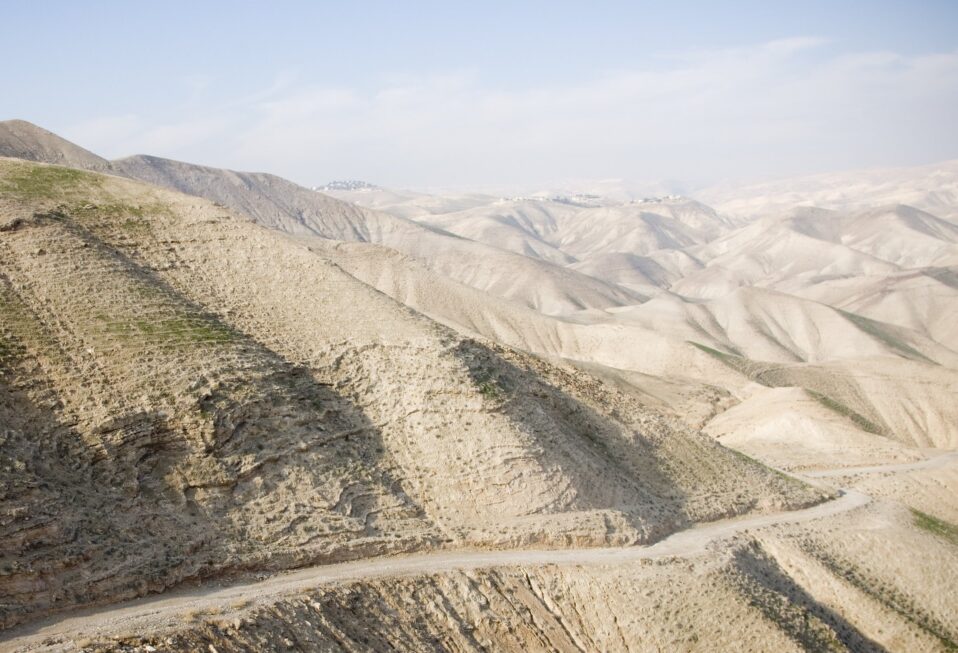
This roadway, which still lay slightly to Jerusalem’s north, followed the route of a canyon system that cuts through the hills to the east of Jerusalem heading down towards Jericho in the Jordan Valley. The main branch of this system, above Jericho, become the Wadi Qilt. At the mouth of the Qilt sat Herod the Great’s winter palace; where, according to the Jewish historian Josephus, Herod died in 4 B.C. Herod’s palace consisted of two parts that straddled the Qilt, and he diverted water from the wadi to serve his pools, bath, and palace needs. 

Jesus passed by Herod’s palace (see Luke 19:11) on His journey to Jerusalem to celebrate Passover. One route Galilean pilgrims took to Jerusalem brought them down the east bank of the Jordan River; they crossed near Jericho, and then ascended to Jerusalem via the roadway that followed the Wadi Qilt. This also served for the setting of the story Jesus told about the man “going down from Jerusalem to Jericho,” who fell among thieves, and eventually a kindly Samaritan helped him (Luke 10:30-37). 

Marc Turnage is President/CEO of Biblical Expeditions. He is an authority on ancient Judaism and Christian origins. He has published widely for both academic and popular audiences. His most recent book, Windows into the Bible, was named by Outreach Magazine as one of its top 100 Christian living resources. Marc is a widely sought-after speaker and a gifted teacher. He has been guiding groups to the lands of the Bible—Israel, Jordan, Egypt, Turkey, Greece, and Italy—for over twenty years.

Website: WITBUniversity.com
Facebook: @witbuniversity
Podcast: Windows into the Bible Podcast

Read more

Biblical Israel: Sepphoris

By Marc Turnage

Sepphoris was the capital of the Galilee during the first part of the 1st century A.D., when Jesus was a boy. Located four miles north of Nazareth, Sepphoris sat in the Beth Netofa Valley, which provided a main east-west roadway in the Lower Galilee from the northwestern part of the Sea of Galilee to Akko-Ptolemias on the Mediterranean coast. Sepphoris consists of an upper and lower city. Within Jewish history, Sepphoris served as the location where Judah the Prince compiled the rabbinic oral teachings into the Mishnah, the earliest body of rabbinic teaching. It was written in Hebrew.

Excavations at Sepphoris uncovered evidence of settlement even as early as the Late Bronze Age and Iron Age I. It seems, however, that a continuous settlement existed at the site from the Persian Period (5th century B.C.) through the Crusader Period. Excavations reveal that during the Roman Period, the western part of the upper city contained Jewish residents, as indicated by the presence of Jewish ritual immersion baths and two oil lamps decorated with menorahs. The upper city also contained a theater set into the northern scarp of the hill, overlooking the Beth Netofa Valley. It could hold about 4500 spectators. Some assign the date of the theater to the 1st century A.D., but most archaeologists date it to the early to mid-2nd century A.D. 

One of the center pieces of the site of Sepphoris is a Roman villa built in the 3rd century A.D. The villa contains a beautiful mosaic floor in its dining room, a triclinium. The center of the mosaic contains scenes depicting the life of the Greek god Dionysius (the god of wine and revelry), including a drinking contest between Dionysius and the hero Heracles. Surrounding the Dionysius scenes are scenes of hunting with wild animals and naked hunters including various flora. In this band of scenes, on the southern end of the mosaic, appears a depiction of a beautiful woman, with either a hunter or Cupid, next to her head. If it is Cupid, then the woman likely is intended to be the goddess Aphrodite. 

Excavations in the lower city have revealed a city planning typical to the Hellenistic-Roman world, a cardo (a north-south street) and a decumanus (an east-west street). Some archaeologists date this urban planning to the 1st century A.D.; others date it to the 2nd century A.D. The cardo and decumanus are flanked by colonnaded sidewalks for pedestrians, with mosaic pavements. Within the lower city, homes, public buildings, as well as a lower city market, have been uncovered. 

Excavators discovered a synagogue in Sepphoris that dates to the 5th century A.D. Its floor is a mosaic that depicts the sun god Helios with his chariot of horses surrounded by a zodiac. Biblical scenes were also depicted although this part of the mosaic was damaged, but it seems to have depicted the story of the binding of Isaac (like the synagogue in Beth Alpha). It remained in use until the 7th century A.D. 

Marc Turnage is President/CEO of Biblical Expeditions. He is an authority on ancient Judaism and Christian origins. He has published widely for both academic and popular audiences. His most recent book, Windows into the Bible, was named by Outreach Magazine as one of its top 100 Christian living resources. Marc is a widely sought-after speaker and a gifted teacher. He has been guiding groups to the lands of the Bible—Israel, Jordan, Egypt, Turkey, Greece, and Italy—for over twenty years.

Website: WITBUniversity.com
Facebook: @witbuniversity
Podcast: Windows into the Bible Podcast

Read more

Biblical Israel: Mount Nebo

By Marc Turnage

Mount Nebo is in the Transjordan (the modern Kingdom of Jordan) in the biblical territory of Moab. From here, Moses viewed the promised land, which he was not permitted to enter due to his disobedience in the Wilderness of Zin (Numbers 20).

God also buried him on Mount Nebo (Deuteronomy 34:1-8). The two and a half tribes that remained east of the Jordan River (Reuben, Gad, and half of the tribe of Manasseh) name Mount Nebo as part of the territory they requested from Moses. Its situation near to the southern end of Gilead (see Deuteronomy 34:1) and within Moab meant that, like other locations along this border, at times it came under the control of Israel and at others the Moabites laid claim to it.

Near to the mountain was a village also named Nebo (Numbers 32:3; 32:38; Isaiah 15:2; Jeremiah 48:1). The preservation of the name of the city aided later travelers and pilgrims in identifying Mount Nebo, which has been identified as such since the 4th century A.D. Byzantine pilgrims routinely visited Mount Nebo and left descriptions as to its location.

Mount Nebo is demarcated by two wadis on the north (Wadi Ayoun Mousa) and south (Wadi Afrit), and the Jordan Valley to the west. It’s highest peak stands at over 2,500 feet above sea level, and none of its peaks are lower than 2,100 feet above sea level.

The two most important peaks are Siyagha in the north (2,130 feet) and Mukhayyat (2,370 feet). Both yield evidence of human presence for thousands of years. From both locations, one has a dramatic view of the Dead Sea, the Jordan Valley and Jericho, and the wilderness of Tekoa to Jerusalem.

Excavations on Siyagha revealed a basilica with mosaics and a monastery that developed around it. So too, excavations on Mukhayyat revealed several Byzantine churches as well.

Marc Turnage is President/CEO of Biblical Expeditions. He is an authority on ancient Judaism and Christian origins. He has published widely for both academic and popular audiences. His most recent book, Windows into the Bible, was named by Outreach Magazine as one of its top 100 Christian living resources. Marc is a widely sought-after speaker and a gifted teacher. He has been guiding groups to the lands of the Bible—Israel, Jordan, Egypt, Turkey, Greece, and Italy—for over twenty years.

Website: WITBUniversity.com
Facebook: @witbuniversity
Podcast: Windows into the Bible Podcast
Read more

Biblical Israel: Southern Steps

By Marc Turnage

Pilgrims to Jerusalem in the first century A.D. approached the Temple Mount from the south. After ritually purifying themselves, either in the Pool of Siloam, at the southern end of the City of David, or in one of the ritual immersion baths located along the southern end of the Temple Mount, pilgrims ascended onto the Temple platform via the southern steps that led through two sets of gates referred to as the Huldah Gates. 

Entering through the Huldah Gates, one came into a double-vaulted entrance hall that led into an ascending tunnel that exited onto the Temple Mount platform. Upon exiting the tunnel, the pilgrim found him or herself standing on a pavement of colorful stones on the southern end of the Temple Mount platform facing the sacred precinct and the Temple itself.

Today visitors to the southern steps of the Temple Mount see remnants of the two sets of gates. The western most of the gates preserves the remains of a double gate, which served as the exit for pilgrims to the Temple. The eastern most set of gates is today a triple gate sealed, most likely, during the Crusader period. This gate was also originally a double gate, and through it, pilgrims entered the Temple. If a pilgrim was in mourning, they reversed their course, entering through the exit and exiting through the entrance, so that other pilgrims could comfort them saying, “May He that dwells in this house give you comfort!”

We hear of Jewish Sages sitting on these steps teaching their students and interacting with pilgrims entering and exiting the Temple. Today, most of the steps have been reconstructed, but a few of the original steps remain exposed. The steps leading up to the Huldah Gates follow a pattern of long, short, long, short. This arrangement makes it difficult for the pilgrim to ascend the steps either running or in great haste. Thus, one must approach the sacred Temple, the house of God, in a circumspect manner. 

South and east of the southern steps archaeologists uncovered a large and unique Jewish ritual immersion bath, a mikveh. Its proximity to the Temple, as well as its unique construction, have led some to suggest that this served the priests for their ritual purification. Other ritual immersion baths have been discovered along the southern end of the Temple Mount, which served Jewish pilgrims who immersed and purified themselves prior to entering the Temple (see Acts 21:24).

Marc Turnage is President/CEO of Biblical Expeditions. He is an authority on ancient Judaism and Christian origins. He has published widely for both academic and popular audiences. His most recent book, Windows into the Bible, was named by Outreach Magazine as one of its top 100 Christian living resources. Marc is a widely sought-after speaker and a gifted teacher. He has been guiding groups to the lands of the Bible—Israel, Jordan, Egypt, Turkey, Greece, and Italy—for over twenty years.

Website: WITBUniversity.com
Facebook: @witbuniversity
Podcast: Windows into the Bible Podcast

Read more

Biblical Israel: Tower of David

By Marc Turnage

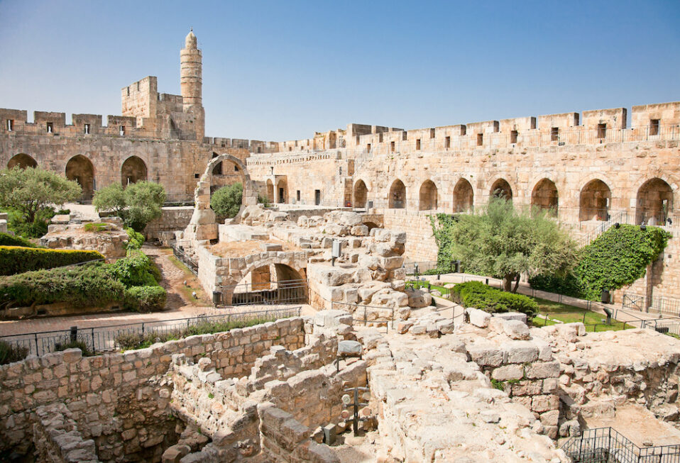
The only gate on the western side of the modern Old City of Jerusalem is Jaffa Gate (so named because the road leading to Jaffa goes through this gate). Inside Jaffa Gate stands the Citadel or the Tower of David. This structure has nothing to do with David, which can confuse modern visitors to Jerusalem. 

The buildings and tower that stands today are built upon the highest point of the city at the end of the Old Testament Period and in the first century. In fact, the wall of the city in these periods turned to the east at this point going towards the area of the Temple Mount. The wall followed a shallow ditch that ran west to east along Jerusalem’s northern boundary. This offered the city’s only natural protection on its northern approach. 

In the first century, Herod the Great chose this strategic location to build his palace in Jerusalem. Its elevated position enabled him to look down over the Temple Mount. Because of the city’s vulnerability to the north, he built three large towers on the northern end of his palace. He named them Phasael (after his brother), Mariamme (after his beloved Hasmonean bride), and Hippicus. The base of one of these three towers forms the base of the Tower of David. 

Herod had palaces throughout his kingdom—Jericho, Caesarea, his palace-fortresses at Masada, and Herodium—but his Jerusalem palace was his largest and most splendid. He decorated it with all kinds of colorful, inlaid stones. Remains of two large pools have been excavated. He built two large building complexes within the palace, one he named Caesareum (after Caesar Augustus, his friend and benefactor) and the other Agrippeum (after Marcus Agrippa, Augustus’ number two man). Herod’s palace had its own aqueduct that provided for its water needs. The aqueduct originated south of Bethlehem. In this palace, Herod would have questioned the wise men seeking the baby Jesus (Matthew 2).

After the death of Herod in 4 B.C., his son Archelaus controlled the lands that included Jerusalem, but when Archelaus was removed by Rome at the request of the Jewish people in A.D. 6, his territory came under the direct rule of the Roman governors. The Roman governors lived in Herod’s palace in Caesarea on the Mediterranean coast. Paul was brought into Herod’s palace in Caesarea, into the Roman governor’s residence (Acts 23:35), which Luke refers to as “the praetorium of Herod.” 

The Roman governors resided in Jerusalem during the Jewish festivals to keep civic order, and they stayed at Herod’s palace. Jesus was brought before Pilate in Jerusalem to the praetorium, which Mark’s Gospel refers to as “the palace” (Mark 15:15). The most likely location in Jerusalem for this encounter was in the palace of Herod the Great. The mention in John’s Gospel of the lithostratos, which is a Greek term meaning “an inlaid stone floor,” further suggests Pilate’s location within Herod’s palace, which Herod had decorated with colorful stones. 

The earliest Christian traditions that follow Jesus’ journey from being beaten to his point of execution follow a route that begins in the area of Herod’s palace to the Church of the Holy Sepulcher, as attested by the Bordeaux Pilgrim. In this way, Herod’s palace serves as a key location at Jesus’ birth and his death.

Marc Turnage is President/CEO of Biblical Expeditions. He is an authority on ancient Judaism and Christian origins. He has published widely for both academic and popular audiences. His most recent book, Windows into the Bible, was named by Outreach Magazine as one of its top 100 Christian living resources. Marc is a widely sought-after speaker and a gifted teacher. He has been guiding groups to the lands of the Bible—Israel, Jordan, Egypt, Turkey, Greece, and Italy—for over twenty years.

Website: WITBUniversity.com
Facebook: @witbuniversity
Podcast: Windows into the Bible Podcast
Read more

Biblical Israel: Damascus Gate

By Marc Turnage

Visitors to the Old City of Jerusalem today can enter the city through seven gates scattered around its eastern, southern, western, and northern sides. These gates, like the walls of the Old City, date to the Ottoman Period (16th-20th centuries). 

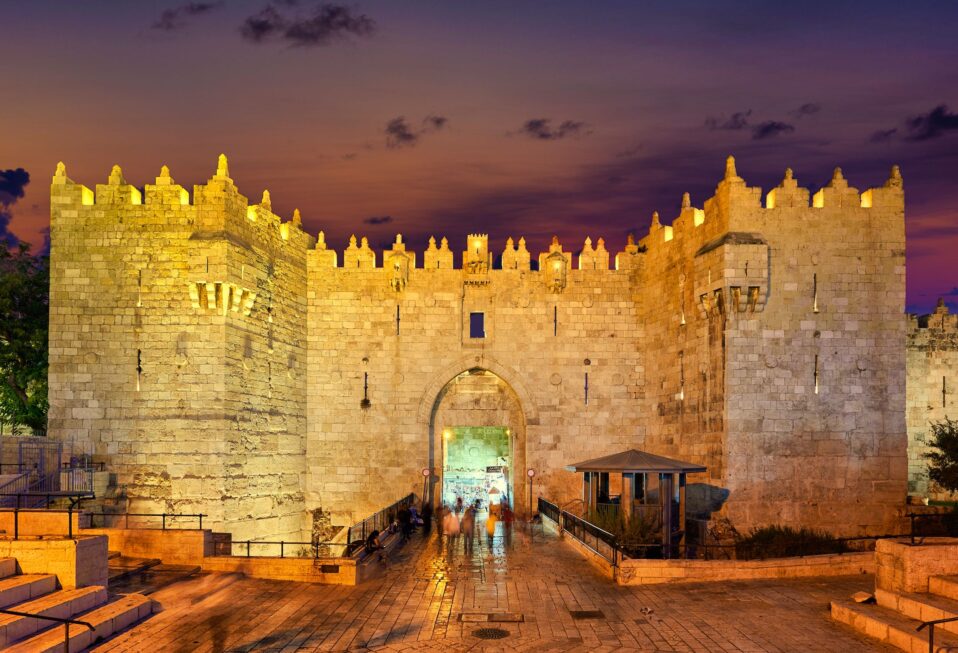
Along the northern stretch of the Old City walls are three gates, from west to east, New Gate, Damascus Gate, and the Flower (or Herod’s) Gate. The current Ottoman Damascus Gate stands upon the remains of a triple-arch gate that dates to the Roman remains of Aelia Capitolina, which was the name given to Jerusalem in the 2nd century A.D. by the Roman Emperor Hadrian. The center arch was the largest, and the two side arches were lower. 

Gates are named for what lies outside of them; therefore, Damascus Gate gains its name because the northern road towards Damascus leads out of the city from there. In Hebrew, the gate is referred to as Shechem Gate because the road to Shechem (modern day Nabulus) led out of the city from there. 

After the destruction of Jerusalem by the Romans in A.D. 70, the city’s footprint changed due to the damage caused by the Roman forces in certain parts of the city, particularly the southern area of the city. This caused the city to shift north and west in the Late Roman Period. From the 2nd century A.D., Jerusalem began to look like a Roman city, which the Old City of Jerusalem more or less parallels until today. 

The Roman Emperor Hadrian renamed Jerusalem, Aelia Captitolina, and the province Judaea, he changed its name to Palestina. As part of the rebuilding of Jerusalem (Aelia Capitolina), the triple-arch, on which Damascus Gate now stands, was constructed. 

This triple-arch gate marked the northern limit of the city. The triple-arch gate was originally free standing, but in the late 3rd century, it was connected to the city’s wall. Entering through the arches, one encountered a paved plaza (similar to what one does entering through today’s Damascus Gate) in which Jerusalem’s two main north-south roadways came together. It seems that a column stood in this plaza, probably with a statue of the emperor on it. 

A mosaic map of the Holy Land in the floor of a church in Maedaba, Jordan that dates to the 6th century A.D. depicts the column, without the statue, standing in the plaza in front of the Damascus Gate. Until today in Arabic, one refers to Damascus Gate as Bab al-‘Amud, the Gate of the Column, which retains the memory of the column in the plaza. 

The triple-arches of the Later Roman Period were built on a stretch of wall that dates back to the first century.

Marc Turnage is President/CEO of Biblical Expeditions. He is an authority on ancient Judaism and Christian origins. He has published widely for both academic and popular audiences. His most recent book, Windows into the Bible, was named by Outreach Magazine as one of its top 100 Christian living resources. Marc is a widely sought-after speaker and a gifted teacher. He has been guiding groups to the lands of the Bible—Israel, Jordan, Egypt, Turkey, Greece, and Italy—for over twenty years.

Website: WITBUniversity.com
Facebook: @witbuniversity
Podcast: Windows into the Bible Podcast

Read more

Biblical Israel: Western Wall

By Marc Turnage

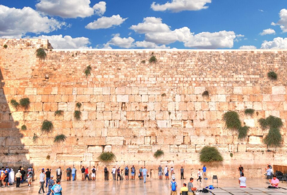
The Western Wall refers to the western retaining wall built to support the Temple Mount platform. In the first century, this wall faced the city of Jerusalem, and as such, it had four gates in it that led onto the Temple Mount platform. 

The gates alternated in their access lower and upper. A street ran along the western wall in the first century. The two lower gates offered access to the Temple Mount from this street. The two high gates were accessed through a bridge and a stairwell supported by a massive arch. 

Today, we refer to these gates by the names of the modern explorers who rediscovered them and identified them. From north to south, they are Warren’s Gate, named after the British explorer Charles Warren. The next gate, accessed by the bridge that led from the Upper City of Jerusalem is Wilson’s Gate, named for the British explorer Charles Wilson. 

The third Gate, which today can be seen on the women’s section of the Western Wall prayer area, is Barclay’s Gate, named for the American missionary doctor, James Barclay. The final gate was named after the American explorer, Edward Robinson. Robinson identified the spring of an arch protruding from the western wall, which was the remains of a large arch that supported a monumental staircase that led onto the Temple Mount. 

Today visitors to Jerusalem encounter three areas of the Western Wall. The most famous in the Western Wall prayer plaza. This has served as a place of Jewish prayer for hundreds of years. It was a small area of the western wall of the Temple Mount retaining wall that was left exposed where Jews could come and pray. 

The Western Wall was not considered holy when the Temple stood but developed into a place of Jewish prayer centuries later. Today it functions as a synagogue and is the most holy site for Jews around the world. Men and women have two separate areas designated for their prayers. 

North of the Western Wall prayer plaza, one can go through a tunnel created by construction in later periods of buildings up against the western wall that follows the Western Wall. In these tunnels one sees the pillars that supported the bridge in the first century leading to Wilson’s Gate; one can even see Warren’s Gate, which is sealed up. 

Following along the tunnel, the first century street is visible in places, as are the massive hewn stones used to build the Western Wall. On the northern end of the tunnel, one encounters a pool, which was an open-air pool in the first century known as the Struthian Pool (or “Sparrow’s Pool”). 

South of the Western Wall plaza, one can walk along the first century street that ran along the Western Wall. On the southwestern corner of the Temple Mount, the spring of Robinson’s Arch is visible as are the small shops where vendors sold sacrifices for the Temple and changed money in the first century. 

The destruction of Jerusalem by the Romans can be seen in a pile of large hewn stones from the Temple Mount, which remains where they fell in the first century. So too, the buckling of the street from the collapse of the walls of the Temple attest to the destruction inflicted by the Romans. 

Marc Turnage is President/CEO of Biblical Expeditions. He is an authority on ancient Judaism and Christian origins. He has published widely for both academic and popular audiences. His most recent book, Windows into the Bible, was named by Outreach Magazine as one of its top 100 Christian living resources. Marc is a widely sought-after speaker and a gifted teacher. He has been guiding groups to the lands of the Bible—Israel, Jordan, Egypt, Turkey, Greece, and Italy—for over twenty years.

Website: WITBUniversity.com
Facebook: @witbuniversity
Podcast: Windows into the Bible Podcast
Read more

Biblical Israel: Mount Tabor

By Marc Turnage

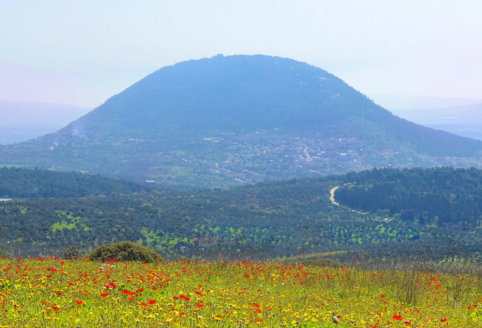
In the northeastern corner of the Jezreel Valley sits the dome shaped hill of Mount Tabor. The steep slopes on all sides of the solitary mountain lead to a plateau on top, 1000 meters by 400 meters in area. The tribal territories of Zebulun, Issachar, and Naphtali meet at Mount Tabor.

Mount Tabor played a prominent role in the story of Deborah and Barak. They gathered the Israelite forces at Mount Tabor prior to their battle with the Canaanite forces of Jabin, king of Hazor, that were led by his general Sisera (Judges 4). The Israelites used the steep slopes of Tabor to their strategic advantage against the Canaanite chariots. So too, their gathering at Tabor prior to the battle may have to do with the connection of the mountain to cultic worship (see Deuteronomy 33:18-19; Hosea 5:1).  

Mount Tabor served as the site for several battles during the Hellenistic and Roman eras. Josephus, who became a historian of ancient Judaism, fortified the mountain as part of his efforts in the Galilee during the First Jewish Revolt against Rome (A.D. 66-73). 

Christian tradition, from the time of the Church Fathers, identified Mount Tabor as a possible location for the site of the event of the Transfiguration. The Gospels do not specify the location of this event, simply calling it “a very high mountain” (Matthew 17:1; Mark 9:2). The earliest tradition identifying Mount Tabor as the location of the Transfiguration comes from the Gospel according to the Hebrews. 

This work no longer exists, but Church Fathers quote passages of it in their works. Origen, citing the Gospel according to the Hebrews, identified the location of the Transfiguration as occurring on Mount Tabor. If this was written in the Gospel according to the Hebrews, then this tradition dates to the late first or early second century A.D. Cyril also knew the tradition that placed the Transfiguration on Mount Tabor. 

Both Eusebius and the Bordeaux Pilgrim do not mention the mountain being a sacred mountain. Thus, while some early Christian traditions located the Transfiguration on Mount Tabor, it was not treated as a sacred mountain or site within the early Byzantine period. Today, visitors to the mountain find a church on its summit.

Marc Turnage is President/CEO of Biblical Expeditions. He is an authority on ancient Judaism and Christian origins. He has published widely for both academic and popular audiences. His most recent book, Windows into the Bible, was named by Outreach Magazine as one of its top 100 Christian living resources. Marc is a widely sought-after speaker and a gifted teacher. He has been guiding groups to the lands of the Bible—Israel, Jordan, Egypt, Turkey, Greece, and Italy—for over twenty years.

Website: WITBUniversity.com
Facebook: @witbuniversity
Podcast: Windows into the Bible Podcast

Read more